Betty Hindley Wreck
| Field |
Value |
| Obstruction Category |
foul ground |
| Status |
Dead = Not detected by numerous sources therefore considered not to exist
|
Betty hindley Wreck Location
Marine Coordinates (DMM)
|
54 16.529 N,0 22.094 W |
Latitude, Longitude
Decimal Degrees
|
- Latitude: 54.275483
- Longitude: -0.368233
|
| Water Depth |
11 m
|
| Water Level Effect |
always under water/submerged |
| Vertical Datum |
Approximate Lowest Astronomical Tide |
| Name |
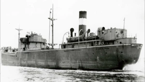
BETTY HINDLEY |
|
Type
|
steam ship
|
| Flag |
GB |
| Length |
78.6 m |
| Width |
11.6 m |
| Draught |
5.2 |
| Tonnage |
1771 |
| Tonnage Type |
gross |
| Cargo |
ballast
|
| Conspic Visual |
not visually conspicuous |
| Conspic Radar |
not radar conspicuous |
| Date Sunk |
Oct 8, 1947
|
| Bottom Texture |
Sand |
| Original Detection Year |
1947 |
| Last Detection Year |
2016 |
| Original Source |
national coast guard or patrol |
| Last Amended Date |
May 25, 2016 |
Surveying Details
H7068/47 9.10.47 SUNK IN 541648N, 002200W. (CG SCARBOROUGH, 8.10.47). INS DW AND GREEN CONL LT BY, GP FL(3)G.10S. - NM 2814/47. H7068/47 19.9.56 LT BUOY WITHDRAWN. (TRINITY HOUSE) - NM 2380/56. H7068/47 9.10.56 LEAST DEPTH OVER WK 30FT IN 541633N, 002159W. (TRINITY HOUSE, 1956) - NM 2553/56. 22.10.70 REPORTED TO BE VERY BROKEN UP IN SEVERAL SEPARATE SECTIONS. MUCH OF IT IS BURIED BY SAND. BOW SECTION IS STILL IN ONE PIECE POINTING UPWARDS FROM THE SEABED. HIGHEST POINT AT A DEPTH OF 30FT. DIVED UPON APPROX AUGUST 1970. (A GODFREY, LTR DTD 15.10.70). 27.9.71 AMEND TO WK 9.1MTRS. NC 1625. 5.12.74 AMEND TO WK 8.5MTRS [LAT]. BR STD. H1283/76/107 1.4.76 REPORTED TO HAVE SUNK ON 7.10.1947. SANK OFF SCARBOROUGH IN 60FT OF WATER. STANDS 25FT OR SO ABOVE THE SEABED. (A GODFREY, LTR DTD 29.3.76). H7068/47 27.2.80 EXAM'D 28.7.79 IN 541631N, 002159.5W [OGB] USING TRISPONDER [2 LOP]. LEAST DEPTH 9.3 IN GEN DEPTH 11.5MTRS. SCOUR 3.0MTRS DEEP. WK COLLAPSED DURING WINTER 1978/79. NOW IN 3 PIECES, OF WHICH ONLY BOWS STAND ABOVE SEABED, STAND 3MTRS HIGH AND ARE UPSIDE DOWN. LEAST DEPTH OBTAINED BY HAND LEAD LINE PLACED ON HIGHEST POINT. (HMS BULLDOG, HI48A/79). AMEND TO WK 9.3MTRS IN REVISED POSN. HH090/730/01 18.11.97 NOT LOCATED BY DCS3 OR E/S BUT MAGNETIC ANOMALY NOTED AT LISTED POSN. WK PRESUMED TO BE BURIED. (GARDLINE, HI 730). AMEND TO FOUL. BR STD. 1.3.06 EUT POSN: 5416.529N, 0021.094W. BA 1612 [6TH EDN, MAY '02]. 22.4.09 EUT POSN RE-EVALUATED: 5416.529N, 0022.094W. SEP 2016/00007250 25.5.16 NOT LOCATED BY M/B. (EGS PIONEER, HI1472). AMEND DEAD.
Circumstances of loss
MINED. VESSEL, BUILT 1943, 3 CYLINDER TRIPLE EXPANSION ENGINE, BOILER. SANK AFTER STRILING A WW2 MINE WHILE ON PASSAGE LONDON TO TYNE. OWNED AT TIME OF LOSS BY CLARKE, STEPHENSON, LONDON. 1 LIFE LOST. (SHIPWRECK INDEX OF BRITISH ISLES)
WRECK MAP LOADING ...
54 16.529 N,0 22.094 W
Betty Hindley on Wreck Map
Betty Hindley Wreck on Google Map
FAQ
Where is the BETTY HINDLEY wreck located?
The BETTY HINDLEY wreck is located at coordinates 54 16.529 N,0 22.094 W.
How deep is the seabed around the BETTY HINDLEY?
The seabed around the BETTY HINDLEY lies at approximately 11 meters deep.
When did the BETTY HINDLEY sink?
The BETTY HINDLEY sank on Oct 8, 1947.
When was the wreck of the BETTY HINDLEY discovered?
The wreck of the BETTY HINDLEY was discovered in 1947.
What country did the BETTY HINDLEY belong to?
The BETTY HINDLEY belonged to GB.
What cargo was the BETTY HINDLEY carrying?
The BETTY HINDLEY was carrying ballast.
What was the tonnage of the BETTY HINDLEY?
The BETTY HINDLEY had a tonnage of 1771 tons.
What type of wreck is the BETTY HINDLEY?
The BETTY HINDLEY is classified as a steam ship.
General Comments
NOW MAGNETIC ANOMALY ONLY