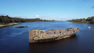
Creteboom Wreck
| Field | Value |
|---|---|
| Wreck Category | wreck showing any portion of hull or superstructure |
|
Creteboom Wreck Location Marine Coordinates (DMM) |
54 8.152 N,9 8.29 W |
| Latitude, Longitude Decimal Degrees |
|
| Water Depth | 0 m |
| Water Level Effect | covers and uncovers |
| Vertical Datum | Approximate Lowest Astronomical Tide |
| Name | CRETEBOOM |
| Type | tug |
| Flag | GB |
| Length | 38.1 m |
| Width | 8.2 m |
| Draught | 4.3 |
| Orientation | 45 |
| Tonnage | 685 |
| Conspic Visual | not visually conspicuous |
| Conspic Radar | not radar conspicuous |
| Date Sunk | Sep 22, 1937 |
| Bottom Texture | Sand |
| Original Detection Year | 1937 |
| Last Detection Year | 1994 |
| Original Source | other |
| Last Amended Date | May 10, 1977 |
Circumstances of loss
22.9.1937 BUILT IN 1919 BY JOHN VER MEHR, SHORHAM, SUSSEX. DUE TO SHORTAGE OF STEEL FERROCONCRETE USED. 154 UNITS ORDERED, INCLUDING 24 TUGS. INTENDED TO TOW BARGES OF IRON ORE FROM SPAIN TO UK. TRIPLE EXPANSION ENGINE, SINGLE SHAFT. WAS ABANDONED IN A YORKSHIRE PORT AND WAS BOUGHT BY MOY HARBOUR COMMISSIONERS, BALIMENA, TO BE SUNK ON THE BAR IN KILLALA BAY TO REDUCE SILTATION. ARRIVED BALLINA ON 22.9.1937. CAME IN LASHED ALONGSIDE A HULL REGISTERED TUG 'PRESSMAN'. WHILST CROSSING THE BAR, DUE TO HEAVY WEATHER, THE VESSELS IMPACTED HEAVILY AND CRETEBOOM WAS CRACKED BELOW THE WATERLINE. DAMAGE NOT SUSPECTED UNTIL ALONGSIDE, WHERE FRANTIC EFFORTS WERE MADE TO KEEP HER AFLOAT, BUT TO NO AVAIL. THE HULL WAS ORDERED AWAY FROM THE JETTY AND SHE SETTLED IN MID STREAM, WHERE SHE REMAINED FOR OVER 30 YEARS. SHE WAS REFLOATED IN THE MID 1970S AND MOVED 25 YARDS TO PRESENT POSITION.
Nearby Wrecks:
- Creteboom Wreck 44 M
- Floweret (Flowerette) Wreck 84 M
- Flowerette Wreck 101.3 M
- Other Wreck 46379 9480.3 M
- M/V Shingle Wreck 13549.9 M
- Thames (Ss) Wreck 14028.8 M
- Other Wreck 44254 23372.4 M
- Other Wreck 46687 26735.2 M
- Other Wreck 46697 27812.8 M
- Hms Racoon Wreck 32172.8 M
General Comments
FERRO CONCRETE HULL