Eskdale Wreck
| Field |
Value |
| Wreck Category |
non-dangerous wreck |
Eskdale Wreck Location
Marine Coordinates (DMM)
|
50 3.196 N,4 54.768 W |
Latitude, Longitude
Decimal Degrees
|
- Latitude: 50.053267
- Longitude: -4.912800
|
| Wreck Depth |
60 m
|
| Water Depth |
67 m
|
| Water Level Effect |
always under water/submerged |
| Vertical Datum |
Approximate Lowest Astronomical Tide |
| Name |
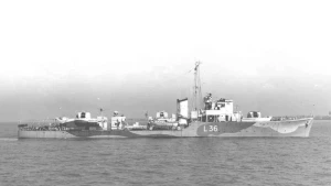
ESKDALE |
|
Type
|
destroyer
|
| Flag |
NO |
| Length |
85.3 m |
| Width |
8.8 m |
| Draught |
2.4 |
| Sonar Length |
50 |
| Sonar Width |
15 |
| Shadow Height |
6.3 |
| Orientation |
17 |
| Tonnage |
1087 |
| Tonnage Type |
gross |
| Conspic Visual |
not visually conspicuous |
| Conspic Radar |
not radar conspicuous |
| Date Sunk |
Apr 14, 1943
|
| Bottom Texture |
Silt |
| Debris Field |
FRAGMENTS LIE 50MTRS & 80MTRS NE |
| Original Detection Year |
1943 |
| Last Detection Year |
2014 |
| Original Source |
other |
| Last Amended Date |
Sep 19, 2014 |
Surveying Details
H67/43 14.4.43 SUNK IN 500330N, 045600W OR 060 DEGS 12M FROM LIZARD PT. (CINC PLYMOUTH, 14.4.43). H4239/73 15.8.74 NOT LOCATED. (HMS HECATE, 1974). H2979/74 18.2.76 FISHERMENS FASTENER IN 500326N, 045624W. POSN BY DECCA. (E GILES, HYDROSERVE LTD. LTR DTD 29.1.76). H3110/72 9.1.73 WK FOUND IN 500310.6N, 045442.3W [OGB] USING HIFIX/3 [2 LOP]. LEAST E/S DEPTH 59.0 IN GEN DEPTH 67MTRS. NO SCOUR. GOOD SONAR CONTACT. FLAT BOTTOM AREA. SEABED OF MUD, SAND, BROKEN SHELL & GRAVEL. (HMS HECATE, 1972). - NM 1002/74. HH100/351/12 3.4.97 DIVED IN 500318.5N, 045442.5W [OGB] USING DECCA. WK FOUND TO BE THAT OF THE NORWEGIAN DESTROYER `ESKDALE'. SHE LIES IN 70MTRS ON HER STARBOARD SIDE WITH THE STERN LYING 100MTRS TO THE EAST. BOWS W. (G J POUND). HH100/351/14 13.8.99 DIVED IN 5003.227N, 0454.742W [WGD] USING GPS. LENGTH 80MTRS, WIDTH 10MTRS. STANDS 8MTRS HIGH. STRONG MAGNETIC ANOMALY. SEABED SILT. (J ROSEVEARE). AMEND TO WK 60MTRS IN REVISED POSN. BR STD. HH100/351/22 16.6.05 LISTS TO STBD SIDE WITH STERN SECTION LYING 100MTRS E. EXTERIOR SECTIONS OF HULL ROTTED LEAVING ENGINES AND INTERIOR EXPOSED. MUNITIONS STILL ON WK. (L BISHOP). SEP 2014/000153151 19.9.14 EXAM'D 21.7.14 IN 5003.196N, 0454.768W [WGD]. LEAST M/B DEPTH 60.7 IN GEN DEPTH 67MTRS. NO SCOUR. LENGTH 50MTRS, WIDTH 15MTRS, HT 6.3MTRS. LIES 017/197 DEGS. STRONG MAGNETIC ANOMALY. TWO ADDITONAL SECTIONS LIE 50MTRS & 80MTRS NE. (MMT, HI 1455). COLLAPSED. RETAIN WK 60MTRS IN REVISED POSN.
Circumstances of loss
BUILT IN 1942 FOR THE ROYAL NAVY BUT LENT TO NORWAY. WAS TORPEDOED AND SUNK BY A GERMAN MTB OFF THE LIZARD WHILE ESCORTING A CONVOY. (DODS).
WRECK MAP LOADING ...
50 3.196 N,4 54.768 W
Eskdale on Wreck Map
Eskdale Wreck on Google Map
FAQ
Where is the ESKDALE wreck located?
The ESKDALE wreck is located at coordinates 50 3.196 N,4 54.768 W.
How deep is the ESKDALE and where exactly is it located?
The ESKDALE lies at a depth of about 60 meters and is located at coordinates 50 3.196 N,4 54.768 W.
How deep is the seabed around the ESKDALE?
The seabed around the ESKDALE lies at approximately 67 meters deep.
When did the ESKDALE sink?
The ESKDALE sank on Apr 14, 1943.
When was the wreck of the ESKDALE discovered?
The wreck of the ESKDALE was discovered in 1943.
What country did the ESKDALE belong to?
The ESKDALE belonged to NO.
What was the tonnage of the ESKDALE?
The ESKDALE had a tonnage of 1087 tons.
What type of wreck is the ESKDALE?
The ESKDALE is classified as a destroyer.
General Comments
COLLAPSED, ?BOWS SW, DEBRIS LIES NE