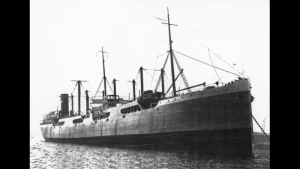
Strombus (Part Of) Wreck
| Field | Value |
|---|---|
| Obstruction Category | foul ground |
|
Strombus (part of) Wreck Location Marine Coordinates (DMM) |
51 34.32 N,3 57.319 W |
| Latitude, Longitude Decimal Degrees |
|
| Wreck Depth | 3.96 m |
| Water Depth | 6 m |
| Water Level Effect | always under water/submerged |
| Vertical Datum | Approximate Lowest Astronomical Tide |
| Name | STROMBUS (PART OF) |
| Type | steam ship |
| Flag | NO |
| Length | 125 m |
| Width | 15.9 m |
| Draught | 9.8 |
| Sonar Length | 43.4 |
| Sonar Width | 6.04 |
| Shadow Height | 2 |
| Orientation | 40 |
| Tonnage | 6549 |
| Tonnage Type | gross |
| Conspic Visual | not visually conspicuous |
| Conspic Radar | not radar conspicuous |
| Date Sunk | Oct 26, 1940 |
| Scour Dimensions | 071.0,,000.4,067.0 |
| Original Detection Year | 1940 |
| Last Detection Year | 2018 |
| Original Source | other |
| Last Amended Date | Jul 3, 2018 |
Circumstances of loss
12.11.42 BUILT IN 1900 BY ARMSTRONG & WHITWORTH CO, NEWCASTLE-UPON-TYNE. OWNED AT TIME OF LOSS BY A/S SEVILLA, ONESIMUS. PASSAGE SWANSEA FOR ANTARCTIC. CARGO COAL & PATENT FUEL. DETONATED A GERMAN-LAID MINE. TUGS TOWED TO SWANSEA AND VESSEL BEACHED. ON 12.11.42 TAKEN TO BRITON FERRY FOR BREAKING BUT FORECASTLE BROKE OFF, DRIFTED AWAY AND CAPSIZED AND STILL LIES ON THE SEABED. IT IS POSSIBLE THAT NONE OF THE VESSEL ARRIVED FOR BREAKING AND THAT THE THREE SECTIONS ARE PARTS OF THE ENTIRE VESSEL. DISPERSED BY EXPLOSIVES BY COSAG DIVING IN 1977. (SIBI).
WRECK MAP LOADING ...
51 34.32 N,3 57.319 W
Strombus (Part Of) on Wreck Map
Strombus (Part Of) Wreck on Google Map
Nearby Wrecks:
- Anchor Wreck 7184 224 M
- Luke John Wreck 400.7 M
- Strombus (Part Of) Wreck 544.5 M
- Protesilaus Wreck 677.6 M
- Riverton (Stern Portion) (Possibly) Wreck 1319 M
- Strombus (Part Of)(Probably) Wreck 1698 M
- Boat Wreck 5705 1720.1 M
- Fort Medine Wreck 1953.1 M
- Beyecharelle Wreck 2046.7 M
- Riptide Wreck 2290.2 M