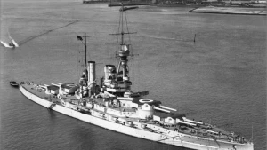
Baden Wreck
| Field |
Value |
| Wreck Category |
non-dangerous wreck |
Baden Wreck Location
Marine Coordinates (DMM)
|
49 50.787 N,2 21.217 W |
Latitude, Longitude
Decimal Degrees
|
- Latitude: 49.846450
- Longitude: -2.353617
|
| Wreck Depth |
152 m
|
| Water Depth |
170 m
|
| Water Level Effect |
always under water/submerged |
| Vertical Datum |
Approximate Lowest Astronomical Tide |
| Name |
BADEN |
|
Type
|
battleship
|
| Length |
189.9 m |
| Width |
30.2 m |
| Sonar Length |
170 |
| Sonar Width |
16 |
| Shadow Height |
19 |
| Orientation |
50 |
| Tonnage |
28075 |
| Tonnage Type |
displacement |
| Conspic Visual |
not visually conspicuous |
| Conspic Radar |
not radar conspicuous |
| Date Sunk |
Aug 17, 1921
|
| Scour Dimensions |
,,001.0, |
| Debris Field |
0100.0,000 |
| Original Detection Year |
1921 |
| Last Detection Year |
2001 |
| Original Source |
national HO/authority wreck information |
| Last Amended Date |
May 23, 2018 |
Surveying Details
H5255/21 25.8.21 SUNK 007DEGS, 7.3M FROM CASQUETS. (C-IN-C PORTSMOUTH, 19.8.21). INS AS OBSOLETE WK SYMBOL IN 495020N, 022120W. BR STD. H1291/28 AMENDED TO NDW (1921). BR STD. H03504/51 28.8.51 A CLEARLY DEFINED OLD WRECK LOCATED IN 495042N, 022106W DURING SEARCH FOR LOST SUBMARINE AFFRAY. (C-IN-C PORTSMOUTH). H03504/51 14.3.60 WRECK LOCATED IN 495042N, 022106W USING A/S DURING SEARCH FOR HMS AFFRAY. NOT DIVED ON. LENGTH 280FT, HEIGHT 23FT. LIES 170/350DEGS. (C-IN-C PORTSMOUTH, 24.7.51). AMEND POSN. BR STD. 11.11.71 AMEND TO USC 28MTRS. NC 3653. H1271/76 2.11.77 AMEND TO USC 100MTRS. [PREVIOUS DEPTH SHOWN UNREALISTIC]. BR STD. 12.2.80 SHOWN AS NDW PA ON FRENCH 878 [DEC'79 EDN, FRENCH WK RECORD NO.14592159]. HH090/496/01 12.10.90 EXAM'D 30.7.90 IN 495047.2N, 022113.0W [WGD] USING HYPERFIX. LEAST E/S DEPTH 152.4 IN GEN DEPTH 170MTRS. SCOUR 1MTR DEEP. DCS3 HT 19MTRS, LENGTH 170MTRS. LIES ON ITS SIDE, ORIENTATED 050/230DEGS WITH HIGH POINT ABOUT A THIRD OF ITS LENGTH FROM S END. TWO SEPARATE, SMALL PIECES OF WRECKAGE, APPROX 4MTRS HIGH, LIE ABOUT 100MTRS N OF WK - COULD BE TWO OF THE FOUR GUN TURRETS. A LARGE MAGNETOMETER DEFLECTION WAS OBSERVED. (NP 1008, HI 496). AMEND TO WK 152MTRS. BR STD. HH090/912/01 21.11.01 LOCATED IN 19.8.01 IN 4950.846N, 0221.159W [WGD] USING DGPS. NOT EXAMINED. LENGTH 160MTRS, WIDTH 25MTRS. DCS3 HT APPROX 25MTRS. LIES 030/210 DEGS WITH BOWS SW. INTACT, ON ITS SIDE. (GARDLINE, HI 912). NCA.
Circumstances of loss
BEACHED IN SINKING CONDITION AT SWANBISTER BAY, SCAPA FLOW IN 1919. RECOVERED AND USED AS GUNNERY TARGET BEFORE BEING FINALLY SUNK. (HOME INTELLIGENCE SUMMARY, NO.34 & JUTLAND TO JUNKYARD BY S C GEORGE).
WRECK MAP LOADING ...
49 50.787 N,2 21.217 W
Baden on Wreck Map
Baden Wreck on Google Map
FAQ
Where is the BADEN wreck located?
The BADEN wreck is located at coordinates 49 50.787 N,2 21.217 W.
How deep is the BADEN and where exactly is it located?
The BADEN lies at a depth of about 152 meters and is located at coordinates 49 50.787 N,2 21.217 W.
How deep is the seabed around the BADEN?
The seabed around the BADEN lies at approximately 170 meters deep.
When did the BADEN sink?
The BADEN sank on Aug 17, 1921.
When was the wreck of the BADEN discovered?
The wreck of the BADEN was discovered in 1921.
What was the tonnage of the BADEN?
The BADEN had a tonnage of 28075 tons.
What type of wreck is the BADEN?
The BADEN is classified as a battleship.
General Comments
LIES ON ITS SIDE