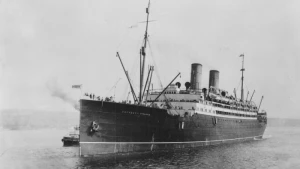
Empress Of Ireland Wreck
| Field | Value |
|---|---|
| Wreck Category | non-dangerous wreck |
|
Empress of ireland Wreck Location Marine Coordinates (DMM) |
48 37.25 N,68 24.22 W |
| Latitude, Longitude Decimal Degrees |
|
| Water Depth | 22 m |
| Water Level Effect | always under water/submerged |
| Vertical Datum | Lowest Astronomical Tide |
| Name | EMPRESS OF IRELAND |
| Type | liner |
| Flag | GB |
| Length | 167.3 m |
| Width | 19.8 m |
| Draught | 11 |
| Tonnage | 14191 |
| Tonnage Type | gross |
| Conspic Visual | not visually conspicuous |
| Conspic Radar | not radar conspicuous |
| Date Sunk | May 29, 1914 |
| Original Detection Year | 1914 |
| Last Detection Year | 1923 |
| Original Source | national HO/authority notice to mariners |
| Last Amended Date | Apr 2, 1985 |
Circumstances of loss
BUILT IN 1906. OWNED AT TIME OF LOSS BY CANDIAN PACIFIC RAILWAY CO. SANK IN 15 MINUTES FOLLOWING A COLLISION IN DENSE FOG WITH NORWEGIAN SS STORSTADT WITH LARGE LOSS OF LIFE. (DODS).
The RMS Empress of Ireland wreck is a National Historic Site of Canada located near Pointe-au-Père (Rimouski), Quebec, on the floor of the St. Lawrence River. The ship was built between 1905 and 1906 and was officially designated a historic site on April 20, 2009.
The ship was operated by Canadian Pacific Steamship Lines and was built by Fairfield Shipbuilding and Engineering in Govan, Glasgow. Designed by Dr. Francis Elgar, it could carry 1,580 passengers in three classes while also transporting Royal Mail between Canada and the United Kingdom.
The Empress of Ireland sank on May 29, 1914, after colliding with the Norwegian cargo ship SS Storstad. The ship sank in just 14 minutes, and 1,012 of the 1,477 people on board lost their lives. This remains the deadliest maritime disaster in Canadian history.
The wreck lies 8.3 km offshore, resting on its starboard (right) side at a 65° angle. It is one of the best-preserved early 20th-century ocean liners in Canada and the only surviving Canadian Pacific Railway ocean liner from before the First World War.
The ship is historically significant because it carried about 117,000 immigrants to Canada between 1906 and 1914. Today, around one million Canadians can trace part of their family history to immigrants who travelled on the Empress of Ireland, making the wreck an important symbol of Canada's immigration history.
Nearby Wrecks:
- St Hilaire Wreck 54352.8 M
- Coudres De L'ile Wreck 62237.9 M
- Saint Adresse Wreck 70589.4 M
- Anchor Wreck 34114 73151.8 M