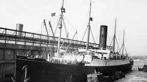
Carpathia Wreck
| Field | Value |
|---|---|
| Wreck Category | non-dangerous wreck |
|
Carpathia Wreck Location Marine Coordinates (DMM) |
49 30.03 N,10 43.04 W |
| Latitude, Longitude Decimal Degrees |
|
| Water Depth | 159 m |
| Water Level Effect | always under water/submerged |
| Vertical Datum | Approximate Lowest Astronomical Tide |
| Name | CARPATHIA |
| Type | liner |
| Flag | GB |
| Length | 164.6 m |
| Width | 19.5 m |
| Draught | 11.3 |
| Tonnage | 13603 |
| Tonnage Type | gross |
| Conspic Visual | not visually conspicuous |
| Conspic Radar | not radar conspicuous |
| Date Sunk | Jul 17, 1918 |
| Original Detection Year | 1918 |
| Last Detection Year | 2001 |
| Original Source | other |
| Last Amended Date | Nov 5, 2014 |
Circumstances of loss
TORPEDOED AND SUNK BY GERMAN SUBMARINE U 55, WHILE ON PASSAGE LIVERPOOL TO THE USA. FIVE OF THE CREW WERE KILLED. 215 SURVIVORS. THE 'CARPATHIA' WAS THE SHIP WHICH HAD RENDERED GREAT SERVICE IN PICKING UP THE SURVIVORS OF THE 'TITANIC'. (DODS & DER KREIG ZUR SEE).
Rescue of Titanic Survivors
On April 11, 1912, the Carpathia left New York City for Fiume with about 740 passengers on board. Early on April 15, around 12:20 a.m., the ship received a distress message from the Titanic. The Titanic had hit an iceberg and was sinking.
Captain Arthur Henry Rostron quickly changed course and headed toward the Titanic, which was about 58 miles (107 km) away. He also got the ship ready to take in survivors. Even though there were icebergs in the area, the Carpathia traveled as fast as it could, reaching the scene at about 3:30 a.m.
By the time it arrived, the Titanic had already sunk more than an hour earlier. Still, the Carpathia rescued 705 people from the lifeboats. The ship then returned to New York City, arriving on April 18.
Captain Rostron and his crew were praised for saving so many lives. For his leadership during the rescue, Rostron received the U.S. Congressional Gold Medal.
Place of Loss: Cape Clear, 124nm SSW
Nearby Wrecks:
- Carpathia Wreck 5175.3 M
- Isis Wreck 10346.3 M
- Isis (Mv) Wreck 10376.2 M
- Isis (Mv) Wreck 12074.7 M
- Pendragon B Wreck 18887 M
- Pendragon B Wreck 18958.6 M
- Estornino Wreck 19266.3 M
- Estornino Wreck 19290.4 M
- Sunderland Wreck 20412.8 M
- Pembroke Wreck 23129.3 M