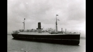
Lancastria Wreck
| Field |
Value |
| Wreck Category |
dangerous wreck |
Lancastria Wreck Location
Marine Coordinates (DMM)
|
47 8.989 N,2 20.417 W |
Latitude, Longitude
Decimal Degrees
|
- Latitude: 47.149817
- Longitude: -2.340283
|
| Wreck Depth |
6.5 m
|
| Water Depth |
16 m
|
| Water Level Effect |
always under water/submerged |
| Vertical Datum |
Approximate Lowest Astronomical Tide |
| Name |
LANCASTRIA |
|
Type
|
liner
|
| Flag |
GB |
| Length |
168.6 m |
| Width |
21.3 m |
| Draught |
11.9 |
| Orientation |
25 |
| Tonnage |
16243 |
| Tonnage Type |
gross |
| Conspic Visual |
not visually conspicuous |
| Conspic Radar |
not radar conspicuous |
| Date Sunk |
Jun 17, 1940
|
| Original Detection Year |
1940 |
| Last Detection Year |
2019 |
| Original Source |
national HO/authority notice to mariners |
| Markers |
R PILLAR LT BUOY, FL(2)R 6 SEC, CLOSE S |
| Last Amended Date |
Aug 30, 2019 |
Surveying Details
H0582/40 27.6.40 DW 193DEGS, 4M FROM LE GRAND CHARPENTIER LT. CHART AS DW IN 470858N, 022027W. - FNM 1604/40. H209/41 22.1.41 G CON BUOYS 185DEGS & 005DEGS, 2C FROM WK. (AUTHORITY NOT STATED). - NM 125/41. 1.12.51 'LANCASTRIA' TO BE DISPERSED. (NID 10885/51). H6379/50 5.9.60 WK REPD AWASH. (PARIS NM 60 22 16). R/S. H6035/45 H6035/45, H4087/45, H6035/45, H2250/60 & H4400/62 CONTAIN BUOYAGE AMENDMENTS. (AUTHORITIES NOT STATED). H927/64 5.11.76 REPD TO HAVE LEAST DEPTH OF ABOUT 4MTRS. (MV VEGAMAN HN 18.10.76). NCA. H2770/69 16.12.80 LEAST DEPTH NOW 10MTRS [5FMS 3FT]. (BREST NM 80 48 36). - NM 44/81. 4.12.82 SHOWN WITH R PILLAR BUOY, VQR, 'LANCASTRIA' ON NC 3216. H2909/85 7.3.86 LEAST DEPTH NOW 11.2MTRS IN 470905N, 022020W [EUR]. (BREST NM 86 06 29 & NM 86 09 29). - NM 1175/86. H4879/84 31.10.86 LEAST DEPTH NOW 8MTRS [4FMS 2FT]. (BREST NM 86 36 23). - NM 3426/86. 7.3.89 POSN ACCURACY 20MTRS. GEN DEPTH 20MTRS BY E/S. (FRENCH WK RECORDS 1987, NO.14572071). 22.3.90 WK IN 470906.8N, 022018.8W [EUR]. POSN ACCURACY 100MTRS. EXAM'D BY SONAR. LEAST DEPTH 8.8MTRS IN GEN DEPTH 18MTRS. WK IN TWO PARTS, LYING ON PORT SIDE. FORE SECTION: LENGTH 50MTRS, BEAM 25MTRS, LYING 215/035DEGS. STERN SECTION: LENGTH 70MTRS, BEAM 25MTRS, LYING 205/025DEGS. HIGHEST POINT IS FORWARD MAST. (FRENCH WK RECORDS 1990, NO.14572071). 15.10.90 SHOWN AS WK 8.8MTRS ON FRENCH 6825. BR STD. 9.1.91 CHART AS WK 8.8MTRS IN 470906.8N, 022018.8W [EUR] MARKED BY PORT HAND PILLAR LT BUOY 'LANCASTRIA', VQ.R, SQUARE TOPMARK CLOSE S. NE 3216. 26.3.96 SHOWN AS WK 8.5MTRS WITH ASSOCIATED BUOYAGE ON FRENCH 7395 [1995 EDN]. BR STD. 11.8.06 SHOWN WITH R PILLAR LT BUOY, FL(2) R 6 SEC, CLOSE S ON BA 2986 [EDN 2 DTD 14.3.02]. SEP 2006/000367375 11.8.06 REST'D AREA RADIUS 200MTRS 'UNDERWATER ACTIVITIES PROHIBITED' ESTABLISHED CENTRED ON WK. (FRENCH NM 22/28/06). - NM 3626/06. SEP 2008/000007504 24.1.08 NOW WK 6.5MTRS. (FRENCH NM 2/16/08). - NM 861/08.
Circumstances of loss
VESSEL, BUILT 1922 BY W BEARDMORE & CO, WAS BOMBED AND SUNK BY GERMAN AIRCRAFT WHILE AT ANCHOR OFF ST NAZAIRE. THE VESSEL HAD APPROX 5300 EVACUATED BRITISH TROOPS AND CIVILIANS ONBOARD, APPROX 2500 WERE SAVED. OWNED AT THE TIME OF LOSS BY CUNARD WHITE STAR LINE. (DODS). ACCOUNT OF LOSS: 'THE LOSS OF THE LANCASTRIA' BY J L WEST.
WRECK MAP LOADING ...
47 8.989 N,2 20.417 W
Lancastria on Wreck Map
Lancastria Wreck on Google Map
FAQ
Where is the LANCASTRIA wreck located?
The LANCASTRIA wreck is located at coordinates 47 8.989 N,2 20.417 W.
How deep is the LANCASTRIA and where exactly is it located?
The LANCASTRIA lies at a depth of about 6.5 meters and is located at coordinates 47 8.989 N,2 20.417 W.
How deep is the seabed around the LANCASTRIA?
The seabed around the LANCASTRIA lies at approximately 16 meters deep.
When did the LANCASTRIA sink?
The LANCASTRIA sank on Jun 17, 1940.
When was the wreck of the LANCASTRIA discovered?
The wreck of the LANCASTRIA was discovered in 1940.
What country did the LANCASTRIA belong to?
The LANCASTRIA belonged to GB.
What was the tonnage of the LANCASTRIA?
The LANCASTRIA had a tonnage of 16243 tons.
What type of wreck is the LANCASTRIA?
The LANCASTRIA is classified as a liner.