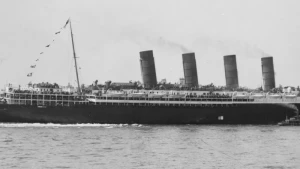
Lusitania Wreck
| Field | Value |
|---|---|
| Wreck Category | non-dangerous wreck |
| Status | historic |
|
Lusitania Wreck Location Marine Coordinates (DMM) |
51 24.745 N,8 32.87 W |
| Latitude, Longitude Decimal Degrees |
|
| Wreck Depth | 77 m |
| Water Depth | 92 m |
| Water Level Effect | always under water/submerged |
| Vertical Datum | Approximate Lowest Astronomical Tide |
| Name | LUSITANIA |
| Type | liner |
| Flag | BRI |
| Length | 232.3 m |
| Width | 26.8 m |
| Draught | 17.4 |
| Sonar Length | 241 |
| Sonar Width | 46 |
| Orientation | 45 |
| Tonnage | 30396 |
| Tonnage Type | gross |
| Cargo | armament,personnel |
| Conspic Visual | not visually conspicuous |
| Conspic Radar | not radar conspicuous |
| Date Sunk | May 7, 1915 |
| Original Detection Year | 1915 |
| Last Detection Year | 2012 |
| Original Source | other |
| Last Amended Date | Sep 29, 2014 |
Circumstances of loss
BUILT IN 1907 BY J BROWN & CO LTD, GLASGOW, WITH S TURBINE, QUADRUPLE SHAFT. OWNED AT TIME OF LOSS BY CUNARD SS COMPANY LTD. PASSAGE NEW YORK FOR LIVERPOOL. CARGO INCLUDED GUNCOTTON, EXPLOSIVES AND SHELLS. TORPEDOED BY GERMAN SUBMARINE U 20. SANK WITHIN 15 MINUTES WITH THE LOSS OF 1198 PASSENGERS AND CREW. (SII). CONSIDERED TO HAVE SUNK DUE TO EXPLOSION IN COAL BUNKERS. (DODS).
Place of Loss: Old Head of Kinsale, 11.8 miles south of, Source of Coordinate: GSI Wreck Data (Wreck No_155), Description: The 30,396-ton Lusitania, together with its sister ship, the Mauritania, was the pride of the Cunard Line when it was built in 1906. The liner was designed by the engineer Leonard Peskett and built by John Brown & Co. Ltd. of Glasgow. It was finished in June 1906 and fitted out for her maiden voyage to New York, which was scheduled for the following September. Its arrival in New York was a major event, with the ship receiving a rapturous welcome and hailed as the finest ship in the world. The building of the Lusitania had stemmed from a low-interest loan given to the owners by the British government, which required fast Atlantic civilian liners capable of being pressed into naval service as auxiliary cruisers at a moment’s notice. The ship was the largest ship ever built at the time, protected by high tensile steel plating, capable of travelling at 25 knots and with its important equipment located below the waterline, to protect it from shellfire during hostilities. Another innovation was the electric controls for steering, detecting fire and closing the watertight compartments, of which there were 175. Four giant steam-turbine engines were fitted instead of the usual reciprocating pistons – the first time a merchant ship had been fitted out in this way. Provision was also made for 12 revolving wheels or gun rings for six 6-inch guns, as well as a number of compartments that could be used as magazines to hold shell stockpiles. There were first-class cabins amidships and the ship was luxuriously fitted out, with the firstclass dining room and smoking room decorated in the neo-classical style of the 18th century.
The second- and third-class accommodation was also of a relatively high standard. In providing this comfort for its less well-off passengers, Cunard was recognising the importance of the large number of third-class passengers, in particular, who would make the one-way journey to America as emigrants, thus bolstering significantly the profits of the Company. Despite these modifications to make the liner suitable for conversion to an auxiliary cruiser, when war broke out in 1914 plans to use the Lusitania as a naval vessel were shelved due to its enormous coal consumption. Having successfully made five return trips to New York from Liverpool following the outbreak of hostilities, the Lusitania was once again en route to Liverpool in May 1915, on her 101st Atlantic crossing. She was carrying 1,257 passengers and 702 crew. While fast liners, like the Lusitania, routinely carried munitions to Britain, in the opinion of the German government, the Lusitania was carrying contraband, in the sense of goods forbidden to be supplied by neutrals to those engaged in war. This is still a controversial issue as under regulations governing American shipping at the time, it was permissible for the Lusitania to be carrying what were termed small arms ammunition, non explosive in bulk. In this regard, the Lusitania carried 1,248 cases of 3.3-inch shrapnel shells (unfilled), 4,927 cases of rifle bullets with around 1,000 cartridges per case, 3,240 percussion fuses for 6-inch shells and 46 tons of aluminium powder. Furthermore, on 30 April, shortly before sailing, 70 passengers and 200 tons of cargo were transferred from the Queen Margaret to the Lusitania, and part of the transferred cargo was ammunition. We know this because the archives of the Remington Arms Company include a letter that refers to the loading of 2,000 cases of small arms ammunition on to the Queen Margaret, and attached to this letter was a Cunard receipt for 2,000 cases of .303 ammunition, with the name Queen Margaret cancelled and Lusitania written across it. Again this has been a source of controversy over the years, but it was apparently common practice for a ship to embark on an abbreviated manifest and to supply a full one after leaving port. In the case of the Lusitania the complete manifest liste
Nearby Wrecks:
- Caliph Wreck 1182.2 M
- Caliph (Ss) Wreck 1240.7 M
- Earl Of Latham (Ss) Wreck 7179.8 M
- Earl Of Lathom Wreck 7227.2 M
- Kilgerran Castle Wreck 7345.6 M
- Kilgerran Castle (Ss) Wreck 7364.7 M
- Lilian H Wreck 8516.7 M
- Lilian H. (Sv) Wreck 8575.9 M
- Dinah B Wreck 11074.3 M
- Spectator (Probably) Wreck 12279.6 M
General Comments
RESTRICTED AREA BOUNDED BY: 5126.40N, 0833.80W [WGD] [NW CORNER]; 5126.40N, 0829.80W [NE CORNER]; 5122.40N, 0833.80W [SW CORNER]; 5122.40N, 0829.80W [SE CORNER].