Hector Gannet Wreck
| Field |
Value |
| Wreck Category |
dangerous wreck |
Hector gannet Wreck Location
Marine Coordinates (DMM)
|
53 0.293 N,1 50.398 E |
Latitude, Longitude
Decimal Degrees
|
- Latitude: 53.004883
- Longitude: 1.839967
|
| Wreck Depth |
20.22 m
|
| Water Depth |
26 m
|
| Water Level Effect |
always under water/submerged |
| Vertical Datum |
Approximate Lowest Astronomical Tide |
| Name |
HECTOR GANNET |
|
Type
|
Platform
|
| Flag |
GB |
| Length |
38.1 m |
| Width |
9.1 m |
| Sonar Length |
35.8 |
| Sonar Width |
17 |
| Shadow Height |
5.8 |
| Orientation |
52 |
| Tonnage |
361 |
| Tonnage Type |
gross |
| Conspic Visual |
not visually conspicuous |
| Conspic Radar |
not radar conspicuous |
| Date Sunk |
Nov 15, 1968
|
| Bottom Texture |
Sand |
| Scour Dimensions |
010.0,018.0,002.0,238 |
| Original Detection Year |
1968 |
| Last Detection Year |
2019 |
| Original Source |
survey vessel |
| Last Amended Date |
May 13, 2020 |
Surveying Details
H7794/68 27.11.68 INS DW IN POSN 305 DEG, 2.25C FROM PLATFORM. (THV MERMAID). - NM 2055/68. H7794/68 12.12.68 LOCATED IN 530007N, 015029E. SWEPT CLEAR AT 49FT, FOUL AT 50FT. THOUGHT TO BE LYING ON PIPELINE. (THV MERMAID). AMEND TO SW 8FMS 1FT. - NM 67/69. H7794/68 16.4.69 WK BELIEVED TO HAVE DRIFTED ONTO AND DAMAGED AS YET UNUSED GAS PIPELINE. AN EFFORT TO MOVE WK ON 31.3.69 FAILED AS IT IS TOO DEEPLY EMBEDDED IN SEABED. (LL 1.4.69). H7794/68 30.4.69 WK TO BE MOVED USING FLOATING CRANE MAGNUS III. (LL 27.4.69). H7794/68 14.5.69 WK MOVED TO POSN 530017N, 015023E. (BOT & LL). H7794/68 23.6.69 EXAM'D 16.5.69. STANDS 33FT ABOVE SEABED WITH 85 DEG LIST. APPROX LEAST DEPTH 45FT [LWST]. (DECCA NAV CO LTD, FOR PHILLIPS PETROLEUM CO LTD). H7794/68 10.9.69 LEAST DEPTH OVER WK (MAST) IS 40FT. THIS IS TO BE CUT DOWN TO 46FT. DEPTH OVER FUNNEL IS 54FT. (PHILLIPS PETROLEUM). H7794/68 4.11.69 MAST REMOVED. HIGHEST POINT NOW FUNNEL CASING AT 60FT. (MAREX DIVING). AMEND TO WK 10FMS. LC 106. H7794/68 16.1.70 POSN NOW 530019.9N, 015029.7E. (PHILLIPS PETROLEUM, 14.11.69). H7794/68 3.2.70 WK MOVED TO 530019.9N, 015029.75E - CLOSE TO WK OF CHEVINGTON. (MAREX DIVING, 14.11.69; BOT, 24.1.70). DELETE. COVERED BY SHOALER WK CLOSE W. HH090/524/01 3.1.92 EXAM'D 10.7.91 IN 530016.4N, 015036.8E [OGB] USING SYLEDIS. SWEPT CLEAR AT 21.4MTRS. NOT FOULED. LEAST E/S DEPTH 20.5 IN GEN DEPTH 24MTRS. SCOUR 4MTRS DEEP. DCS3 HT 4.6MTRS, LENGTH 45MTRS, WIDTH 10MTRS. LIES 050/230 DEG WITH HULL APPARENTLY INTACT. POSSIBLE DEBRIS LIES TO W OF WK. SWEPT CLEAR TO 1.8MTRS BELOW LEVEL OF SANDWAVES SOME 40MTRS TO N OF WK. (LAND & MARINE, HI 525). CHART COMBINED WITH WK CLOSE W. SHOW AS SW (WKS) 15.3MTRS IN 530016N, 015031E (MEAN POSN OF CHEVINGTON AND HECTOR GANNET). BR STD.POSITIONS BELOW THIS POINT ARE IN DEGREES, MINUTES AND DECIMALS OF A MINUTE 10.6.02 RECORD REVIEWED. AMEND TO SW WK 21MTRS. BR STD. SEP 2020/000100123 13.5.20 EXAM'D 22.02.19; IN 5300.293N, 0150.398E [WGD]. LEAST M/B DEPTH 20.22MTRS IN GEN DEPTH 26MTRS, LENGTH 35.8MTRS, WIDTH 17MTRS, HEIGHT 5.8MTRS, ORIENTATION 052/232 DEGS. SCOUR LENGTH 10MTRS, WIDTH 18MTRS, 2MTRS DEEP, TOWARDS 238 DEGS. WRECK SITS UPRIGHT, LISTING TO PORT. AFT SECTION IS VISIBLE AND INTACT, WITH FORWARD SECTION BURIED BY SAND WAVE. (MERITAITO, HI 1580). AMEND DW 20.2MTRS IN REVISED POSN.
Circumstances of loss
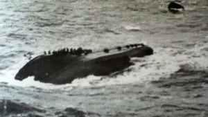
BUILT IN 1962. HOME PORT GT YARMOUTH. A TM STERN TRAWLER EMPLOYED AS SAFETY VESSEL FOR HEWETT A DRILLING PLATFORM. WAS SEVERELY DAMAGED, CAPSIZED AND SANK WHILE ATTEMPTING TO RESCUE PLATFORM CREW FOLLOWING A GAS BLOWOUT.
WRECK MAP LOADING ...
53 0.293 N,1 50.398 E
Hector Gannet on Wreck Map
Hector Gannet Wreck on Google Map
FAQ
Where is the HECTOR GANNET wreck located?
The HECTOR GANNET wreck is located at coordinates 53 0.293 N,1 50.398 E.
How deep is the HECTOR GANNET and where exactly is it located?
The HECTOR GANNET lies at a depth of about 20.22 meters and is located at coordinates 53 0.293 N,1 50.398 E.
How deep is the seabed around the HECTOR GANNET?
The seabed around the HECTOR GANNET lies at approximately 26 meters deep.
When did the HECTOR GANNET sink?
The HECTOR GANNET sank on Nov 15, 1968.
When was the wreck of the HECTOR GANNET discovered?
The wreck of the HECTOR GANNET was discovered in 1968.
What country did the HECTOR GANNET belong to?
The HECTOR GANNET belonged to GB.
What was the tonnage of the HECTOR GANNET?
The HECTOR GANNET had a tonnage of 361 tons.
What type of wreck is the HECTOR GANNET?
The HECTOR GANNET is classified as a platform.
General Comments
INTACT