Hindenburg Wreck
| Field |
Value |
| Obstruction Category |
foul ground |
Hindenburg Wreck Location
Marine Coordinates (DMM)
|
58 52.572 N,3 11.202 W |
Latitude, Longitude
Decimal Degrees
|
- Latitude: 58.876200
- Longitude: -3.186700
|
| Wreck Depth |
15.3 m
|
| Water Depth |
18 m
|
| Water Level Effect |
always under water/submerged |
| Vertical Datum |
Approximate Lowest Astronomical Tide |
| Name |
HINDENBURG |
|
Type
|
battle-cruiser
|
| Flag |
DE |
| Length |
210 m |
| Width |
29 m |
| Draught |
8.2 |
| Sonar Length |
55 |
| Sonar Width |
10 |
| Shadow Height |
3 |
| Orientation |
85 |
| Tonnage |
26180 |
| Tonnage Type |
displacement |
| Conspic Visual |
not visually conspicuous |
| Conspic Radar |
not radar conspicuous |
| Date Sunk |
Jun 21, 1919
|
| Original Detection Year |
1919 |
| Last Detection Year |
2010 |
| Original Source |
other |
| Last Amended Date |
Jun 5, 2025 |
Surveying Details
H8464/19 DWP, LEAST DEPTH 4.5FMS, MAST SHOWING IN 585238N, 031107W ON SURVEY [C7953]. INS AS DWP 4.5FMS (MAST) (1919). BR STD. H6229/23 13.7.23 INS ON NE 3729 - NM 1523/23. H143/26 CP23187/26 CP23829/26 CP24906/26 CP25580/26 CP26151/26 SALVAGE OPS. - TNM 1402/26. H143/26 CP32412/26 CP10246/26 CP13971/26 CP14895/26 CP19433 SALVAGE OPS. - TNM 1672/26. CP28552/29 SALVAGE TO RECOMMENCE MARCH 1930. H2303/30 8.8.30 WK IN MILL BAY. 2 CONCRETE BLOCKS USED FOR STEADYING STILL IN POSN. H2303/30 19.8.30 WK REMOVED. POSN 585238N, 031107W REMAINS FOUL. (AUTHORITY NOT STATED). AMEND TO FA. - NM 1357/30. H2303/30 20.9.30 2 CONCRETE BLOCKS HAVE 9FMS OVER THEM. (AUTHORITY NOT STATED). 21.12.30 CP28255 21.12.30 GENERAL REPORT ON SALVAGE. 22.7.30 RAISED 22.7.30. (JUTLAND TO JUNKYARD, S.C. GEORGE). 26.9.80 SHOWN AS FOUL GROUND. NC 35. 28.1.05 LEGEND: 'FOUL GROUND' SHOWN CENTRED ON 5852.629N, 0311.222W [WGD] ON BA 35 [EDN 5 DTD 27.3.03]. 7.10.10 EXAM'D IN 5852.571N, 0311.201W [WGD] USING DGPS. LEAST M/B DEPTH 15.37MTRS. (FATHOMS LTD, POST SDC BATHY REPROCESSING). LENGTH APPROX 55MTRS, WIDTH 10MTRS, HT 3MTRS. LIES 085/265 DEGS. APPEARS AS TWO LINKED MOUNDS, ?DEBRIS. AMEND FOUL 15.3MTRS. RETAIN LEGEND 'FOUL GROUND' CLOSE BY. BR STD. RSDRA2025000126343 02.04.25 LOCATED IN M/B DATASET 2023. LEAST M/B DEPTH 15.73MTRS. DEEPER THAN CHARTED. NFS. (ORKNEY ISLAND COUNCIL, M/B SURVEY, DTD 2023). RETAIN FOUL 15.3MTRS.
Circumstances of loss
SCUTTLED
WRECK MAP LOADING ...
58 52.572 N,3 11.202 W
Hindenburg on Wreck Map
Hindenburg Wreck on Google Map
FAQ
Where is the HINDENBURG wreck located?
The HINDENBURG wreck is located at coordinates 58 52.572 N,3 11.202 W.
How deep is the HINDENBURG and where exactly is it located?
The HINDENBURG lies at a depth of about 15.3 meters and is located at coordinates 58 52.572 N,3 11.202 W.
How deep is the seabed around the HINDENBURG?
The seabed around the HINDENBURG lies at approximately 18 meters deep.
When did the HINDENBURG sink?
The HINDENBURG sank on Jun 21, 1919.
When was the wreck of the HINDENBURG discovered?
The wreck of the HINDENBURG was discovered in 1919.
What country did the HINDENBURG belong to?
The HINDENBURG belonged to DE.
What was the tonnage of the HINDENBURG?
The HINDENBURG had a tonnage of 26180 tons.
What type of wreck is the HINDENBURG?
The HINDENBURG is classified as a battle-cruiser.
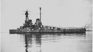
General Comments
TWO LINKED MOUNDS, ?DEBRIS. COVERS [1071]