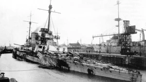
Seydlitz Wreck
| Field |
Value |
| Obstruction Category |
foul ground |
| Status |
Not Fully Surveyed
|
Seydlitz Wreck Location
Marine Coordinates (DMM)
|
58 52.185 N,3 10.95 W |
Latitude, Longitude
Decimal Degrees
|
- Latitude: 58.869750
- Longitude: -3.182500
|
| Wreck Depth |
15.52 m
|
| Water Depth |
19 m
|
| Water Level Effect |
always under water/submerged |
| Vertical Datum |
Approximate Lowest Astronomical Tide |
| Name |
SEYDLITZ |
|
Type
|
battle-cruiser
|
| Flag |
DE |
| Length |
199.9 m |
| Width |
28.3 m |
| Draught |
8.2 |
| Sonar Length |
11 |
| Sonar Width |
9 |
| Shadow Height |
3.75 |
| Orientation |
95 |
| Tonnage |
24610 |
| Tonnage Type |
displacement |
| Conspic Visual |
not visually conspicuous |
| Conspic Radar |
not radar conspicuous |
| Date Sunk |
Jun 21, 1919
|
| Original Detection Year |
1919 |
| Last Detection Year |
2023 |
| Original Source |
national HO/authority charts |
| Last Amended Date |
Jun 4, 2025 |
Surveying Details
H8464/19 STF (20FT HIGH) SHOWN IN 585212N, 031053W ON SURVEY [C7953]. INS AS STF (1919) (20FT HIGH) ON FLEET CHARTS. H6229/23 13.7.23 INS ON NE 3729. - NM 1523/23. CP 30134/24 HANDED OVER TO MESSRS COX AND DANKS. CP 18818/28 SALVAGE REPORT. (KHM SCAPA FLOW). CP 20513/28 10.8.28 FURTHER REPORT ON SALVAGE, BLASTING AWAY OF UPPER WORKS STILL IN PROGRESS. CP 26491/28 FURTHER DETAILS RE SALVAGE OF WK. RAISED AND BEING TOWED TO LYNESS PT. CP 28168/28 5.12.28 SAFELY TOWED TO LYNESS PT. TRACING WILL BE FORWARDED OF EXACT POSN. CP 290/29 8.1.29 POSN AT LYNESS PT ALTERED. NOW MOVED FURTHER INSHORE FURTHER. ALTERATION OF POSN INTENDED. NOT YET READY FOR SEA. H270/29 15.1.29 WK NO LONGER CHARTED. - NM 214/29. CP 9692/29 26.4.29 SEYDLITZ WILL LEAVE FOR ROSYTH UNDER TOW ON 30.4.29 OR 1.5.29. CP 10598/29 16.5.29 TOWED TO ROSYTH. SUPERSTRUCTURE CUT AWAY AND LEFT. 2.11.28 RAISED 2.11.28. (JUTLAND TO JUNKYARD, S C GEORGE). 23.10.39 ORIGINAL POSN NOW CHARTED AS FOUL ANCHORAGE. NC 35. 2.7.80 NOW CHARTED AS FOUL GROUND. H1310/82 1.11.82 PARTS OF SUPERSTRUCTURE REMAIN IN THIS POSN, TOGETHER WITH SALVAGE EQUIPMENT SUCH AS HOSES AND FITTINGS. A HEAP OF COAL, ESTIMATED AT 4000 TONS, REMAINS ON SITE, PRESUMABLY HER BUNKERS. (B WINFIELD, 25.10.82). NCA. HH100/351/21 30.1.04 DIVED IN LISTED POSN. LARGE AMOUNT OF SCRAP METAL SOME 50-75MTRS IN RADIUS, STANDING 2MTRS HIGH. CONSISTS OF PLATES, GIRDERS AND PIPES. SMALL PIECES OF COAL FOUND OVER A LARGE AREA. (CPO JACKSON, NACSAC). NCA. 7.10.10 EXAM'D IN 5852.1836N, 0310.9490W [WGD] USING DGPS. LEAST M/B DEPTH 16.45MTRS. (FATHOMS LTD, POST SDC BATHY REPROCESSING). AREA OF DEBRIS, LENGTH APPROX 250MTRS, WIDTH 70MTRS. LIES 095/275 DEGS. HIGH POINT TO N. AMEND FOUL 16.4MTRS IN REVISED POSN, RETAIN LEGEND 'FOUL' CLOSE N. BR STD. RSDRA2025000126343 01.04.25 FOUL FOUND 2023; LOCATED IN 5852.185N, 00310.950W (WGD). LEAST M/B DEPTH 15.52MTRS IN GEN DEPTH 19MTRS. LENGTH 3.75MTRS, WIDTH 11MTRS, HEIGHT 9MTRS. NFS. (ORKNEY ISLAND COUNCIL, M/B SURVEY, DTD 2023). AMEND FOUL 15.5MTRS IN REVISED POSN.
Circumstances of loss
SCUTTLED.
WRECK MAP LOADING ...
58 52.185 N,3 10.95 W
Seydlitz on Wreck Map
Seydlitz Wreck on Google Map
FAQ
Where is the SEYDLITZ wreck located?
The SEYDLITZ wreck is located at coordinates 58 52.185 N,3 10.95 W.
How deep is the SEYDLITZ and where exactly is it located?
The SEYDLITZ lies at a depth of about 15.52 meters and is located at coordinates 58 52.185 N,3 10.95 W.
How deep is the seabed around the SEYDLITZ?
The seabed around the SEYDLITZ lies at approximately 19 meters deep.
When did the SEYDLITZ sink?
The SEYDLITZ sank on Jun 21, 1919.
When was the wreck of the SEYDLITZ discovered?
The wreck of the SEYDLITZ was discovered in 1919.
What country did the SEYDLITZ belong to?
The SEYDLITZ belonged to DE.
What was the tonnage of the SEYDLITZ?
The SEYDLITZ had a tonnage of 24610 tons.
What type of wreck is the SEYDLITZ?
The SEYDLITZ is classified as a battle-cruiser.