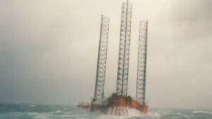
West Gamma Wreck
| Field |
Value |
| Wreck Category |
dangerous wreck |
West gamma Wreck Location
Marine Coordinates (DMM)
|
54 56.443 N,6 39.17 E |
Latitude, Longitude
Decimal Degrees
|
- Latitude: 54.940717
- Longitude: 6.652833
|
| Wreck Depth |
25 m
|
| Water Depth |
40 m
|
| Water Level Effect |
always under water/submerged |
| Vertical Datum |
Lowest Astronomical Tide |
| Name |
WEST GAMMA |
|
Type
|
Platform
|
| Flag |
NO |
| Length |
70.1 m |
| Width |
64.6 m |
| Tonnage |
11514 |
| Tonnage Type |
gross |
| Conspic Visual |
not visually conspicuous |
| Conspic Radar |
not radar conspicuous |
| Date Sunk |
Aug 21, 1990
|
| Original Detection Year |
1990 |
| Last Detection Year |
2019 |
| Original Source |
national HO authority radio navigational warning |
| Last Amended Date |
Apr 4, 2019 |
Surveying Details
HH160/351/01 4.9.90 LIES PARTLY VISIBLE IN 545627N, 063919E. MARKED BY N AND S CARDINAL LIGHT BUOYS. (SEEWARN CUXHAVEN, NAV WARNING NO.565). NAVAREA I 266/90 ISSUED. NCA YET. HH160/351/01 1.10.90 REFERRED TO AS A WK, DANGEROUS TO NAVIGATION, MARKED BY N CARD, VQ, 500MTRS N, AND S CARD, VQ(6)+LFL, 500MTRS S. (HAMBURG NM T(21)50/35/90). WK IS REPORTED TO BE LEAKING OIL. OWNERS HAVE YET TO MAKE ANY ARRANGEMENTS FOR SALVAGE. (LL 11.9.90). NCA YET. HH160/351/01 19.10.90 SETTLED AS A CONSTRUCTIVE TOTAL LOSS. (LL 6.10.90). HH160/351/01 5.2.91 SW 2MTRS IN 545629N, 063915E [EUR]. MARKED BY N CARD, VQ, 500MTRS N; E CARD, Q(3) 10S, 500MTRS E; S CARD, VQ(6)+LFL, 500MTRS S; AND W CARD, Q(9) 15S, RACON (D), 500MTRS W. RESTRICTED AREA, 1.5 MILES RADIUS, CENTRED ON WK. (HAMBURG NM (21)50/48/90). - NM 490/91. HH328/470/01 6.5.94 SALVAGE OPERATIONS IN PROGRESS. HH326/001/94 18.5.94 (T) NOTICE 'SALVAGE WORK - GIVE WIDE BERTH' ISSUED. (HAMBURG NM T(20) 1001). HH328/470/01 6.9.94 LIGHT BUOYS WITHDRAWN. (CUXHAVEN TLX 31.8.94). NCA. HH328/470/01 8.9.94 NOW SW 25.2MTRS IN 545629N, 063915E [EUR]. BUOYS WITHDRAWN. (SEEWARN CUXHAVEN, TLX DTD 7.9.94). AMEND SW 25MTRS, DEL BUOYS & REST'D AREA. - NM ACTION. SEP 2015/000158093 19.2.16 SHOWN AS SW 25MTRS IN 5456.443N, 0639.170E [WGD] ON DE221000. (EDN 7.0, DTD 10.7.15). NFA.
Circumstances of loss
EX-DRILLING PLATFORM DYVI GAMMA. A SELF-ELEVATING ACCOMMODATION PLATFORM. BROKE ADRIFT FROM MOORINGS DURING A VIOLENT STORM IN WHICH THE HELICOPTER PLATFORM WAS BLOWN AWAY. WAS ABANDONED BY CREW AND EVENTUALLY CAPSIZED AND SANK. (LL).
WRECK MAP LOADING ...
54 56.443 N,6 39.17 E
West Gamma on Wreck Map
West Gamma Wreck on Google Map
FAQ
Where is the WEST GAMMA wreck located?
The WEST GAMMA wreck is located at coordinates 54 56.443 N,6 39.17 E.
How deep is the WEST GAMMA and where exactly is it located?
The WEST GAMMA lies at a depth of about 25 meters and is located at coordinates 54 56.443 N,6 39.17 E.
How deep is the seabed around the WEST GAMMA?
The seabed around the WEST GAMMA lies at approximately 40 meters deep.
When did the WEST GAMMA sink?
The WEST GAMMA sank on Aug 21, 1990.
When was the wreck of the WEST GAMMA discovered?
The wreck of the WEST GAMMA was discovered in 1990.
What country did the WEST GAMMA belong to?
The WEST GAMMA belonged to NO.
What was the tonnage of the WEST GAMMA?
The WEST GAMMA had a tonnage of 11514 tons.
What type of wreck is the WEST GAMMA?
The WEST GAMMA is classified as a platform.